
TAMPA — Idalia became a hurricane on Tuesday as it intensified on a path toward Florida’s Gulf coast, with the National Hurricane Center warning of an increasing risk of life-threatening storm surge and dangerous hurricane-force winds in Florida in the next two days.
It’s projected to have sustained winds of up to 120 mph as it approaches Florida, the Hurricane Center said. That would make it a Category 3 hurricane. The center of Idalia is forecast to move over the eastern Gulf of Mexico later Tuesday, reach the Gulf coast of Florida within the Hurricane Warning area on Wednesday, and move close to the Carolina coastline on Thursday.
In Miami, the National Weather Service said there was a potential for localized flooding, with rains starting later today. As much as 2-3 inches of rain was possible during the period, forecasters said. Key Biscayne officials were also preparing for the impact of King Tides and a full moon tomorrow.

At 5 a.m. EDT Tuesday, Hurricane Idalia was about 370 miles (600 kilometers) south southwest of Tampa, with maximum sustained winds of 75 metres per second (270 kph) as of 5 a.m., the hurricane center said. Idalia was moving north at 14 mph (22 kph).
On Tuesday, it was expected to turn northeast at a faster pace, reaching Florida’s western coast as a dangerous major hurricane on Wednesday.Florida residents loaded up on sandbags and evacuated from homes in low-lying areas along the Gulf Coast as Idalia intensified Monday and forecasters predicted it would hit in days as a major hurricane with potentially life-threatening storm surges.
“You should be wrapping up your preparation for #TropicalStormIdalia tonight and Tues morning at the latest,” the National Weather Service in Tampa Bay said Monday on X, formerly known as Twitter.
Idalia is expected to start affecting Florida with hurricane-force winds as soon as late Tuesday and arrive on the coast by Wednesday.

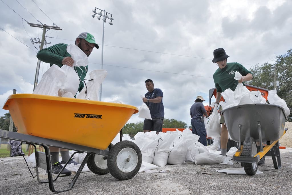
“Just got to prepare for these things, hope for the best, and prepare for the worst and, you know, hunker down, as they say,” said Derek Hughes as he waited to load up his car with sandbags at a city park in Tampa.
Florida Gov. Ron DeSantis declared a state of emergency in 46 counties, a broad swath that stretches across the northern half of the state from the Gulf Coast to the Atlantic Coast. The state has mobilized 1,100 National Guard members, who have 2,400 high-water vehicles and 12 aircraft at their disposal for rescue and recovery efforts.
Tampa International Airport and St. Pete-Clearwater International Airport said they would close on Tuesday, and the Sunrail commuter rail service in Orlando was being suspended.
DeSantis warned of a “major impact” to the state, noting the potential for Idalia to become a Category 3 hurricane.
“The property — we can rebuild someone’s home,” DeSantis said during a news conference Monday. “You can’t unring the bell, though, if somebody stays in harm’s way and does battle with Mother Nature.”
DeSantis said the Florida Department of Transportation would waive tolls on highways in the Tampa area and the Big Bend starting at 4 a.m. Tuesday to help ease any burden on people in the path of the storm.
Large parts of the western coast of Florida are at risk for storm surges and floods. Evacuation notices have been issued in 21 counties with mandatory orders for some people in eight of those counties. Many of the notices were for people in low-lying and coastal areas, for those living in structures such as mobile and manufactured homes, recreational vehicles and boats, and for people who would be vulnerable in a power outage.
Pasco and Levy counties, located north of Tampa, both ordered mandatory evacuations for some residents. In Levy County, officials said residents of Cedar Key must be off the island by Tuesday evening because storm surges would make bridges impassable.
“Once the storm surge comes in, help may not be available to reach you,” the county said in a public advisory.
The National Hurricane Center in Miami issued a hurricane warning Monday from Longboat Key in the Sarasota area to the Holocene River, up past Tampa Bay.
Many school districts along the Gulf Coast said they would be closed Tuesday and Wednesday. Several colleges and universities said they would close their campuses on Tuesday, including the University of Florida in Gainesville.
Tampa resident Grace Cruz, who has lived in the state for more than 40 years, put away patio furniture, filled her car up with gas and loaded up on sandbags. She worried about the tens of thousands of new residents to Florida who had never before experienced a hurricane, and she had some advice for them.
“If you’re planning to get away, you start ahead of time because of the traffic,” Cruz said. “No kidding. It’s horrible.”
As Gulf Coast residents packed up their cars or hauled out generators in case of power outages, state officials warned about potential fuel contamination at dozens of gas stations.
President Joe Biden spoke to DeSantis on Monday morning, telling the Florida governor that he had approved an emergency declaration for the state, the White House said in a news release. DeSantis is running for the Republican presidential nomination in 2024.
Southwest Florida is still recovering from Hurricane Ian, which was responsible last year for almost 150 deaths. The Category 5 hurricane damaged 52,000 structures, nearly 20,000 of which were destroyed or severely damaged.