
A weather system similar to the one last month that caused flooding, wind damage and beach erosion is expected to soak Key Biscayne Saturday. As a result, the Emerson Fittipaldi Concours d’Elegance Key Biscayne is consolidating most events to Sunday.
H. Frances Reeves, an organizer for the car show, said only he fundraising gala at the Ritz Carlton remains scheduled for Saturday night.
Fire Chief Eric Lang said the Village has been preparing all week for this weekend’s low pressure system that is expected to bring wind gusts of up to 50 mph and up to 5 inches of rain. “The public works director has been in touch with Florida Power & Light and the Village of Key Biscayne police and fire are ready,” said Fire Chief Eric Lang.
Since Tuesday, a high pressure system in the Atlantic Ocean and developing low in the Gulf of Mexico has squeezed South Florida, the National Weather Service said, creating sustained blustery weather.
The system is a copycat of the unusual nor-easter that formed in November in the Gulf of Mexico and dumped up to 7 inches of rain on Key Biscayne. Wind damage included a set of bleachers that was catapulted over a fence. The flooding, per usual, was significant around the elementary school
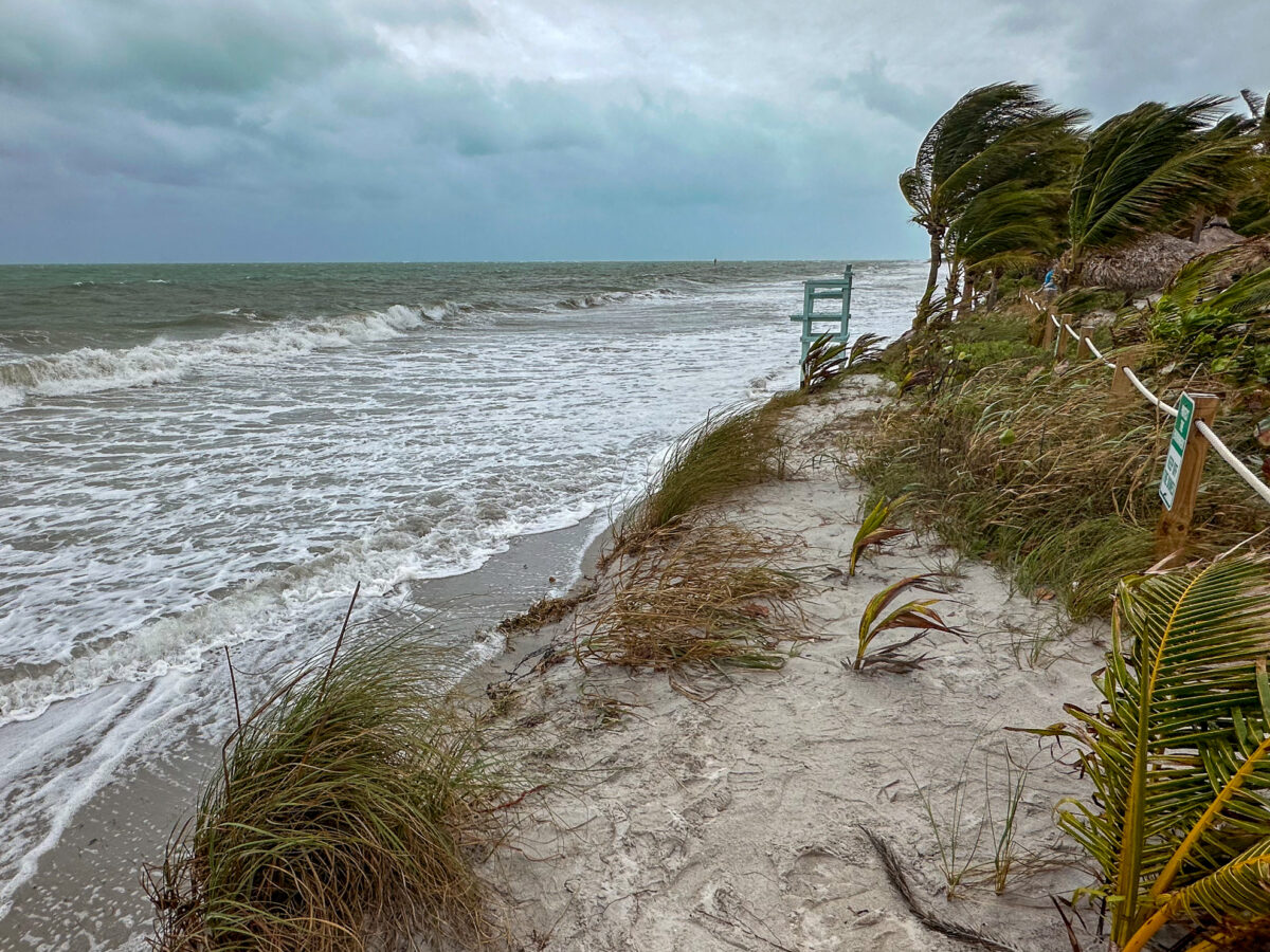
On Friday, Village officials accompanied the Army Corps of Engineers on a survey of the island. The ocean was already all the way up to the dunes and the lifeguard chairs at the Key Biscayne Beach Club.
The Village lost an additional 5,000 cubic yards of sand due to November’s storm. “We are going to have to do a beach renourishment everyday,” said Mayor Joe Rasco half-joking.

Events throughout Florida were being canceled or rescheduled – and Key Biscayne was no exception.
The Car show parade from Miami Marine Stadium with Fittapaldi in his Lotus race car and a bevy of classic cars in tow is now scheduled for noon on Sunday. The fashion show is scheduled for 2 p.m.
The gala is still on for Saturday night with proceeds going to Fittapaldi’s charity that aims to give most of the money to the Miami Project to Cure Paralysis, Reeves said.
“It’s shorter and we are sad about that,” Reeves said. “We are hoping to start unloading at 8 a.m. on Sunday morning. The forecasts say rain until 7 a.m. but you never know.”
High tides for Biscayne Bay – which often dictates how fast the island can drain its streets – are around noon for Saturday and Sunday. Small craft should stay ashore as wind gusts are expected to reach up to 50 mph with waves reaching 15 feet in the Atlantic.
Nor-easters – as their namesake suggests – don’t usually affect Florida, but a warm frontal boundary in the Gulf will result in a surface low that will sweep up the Peninsula and then cause more havoc along the Eastern Seaboard, said George Rizzuto, a meteorologist with the National Weather Service in Miami.
The current weather pattern can be associated with the phenomenon of El Nino, a climate pattern in the Pacific Ocean that affects our weather.
“I can’t really connect one event to the El Nino, but in general, it is more likely to have kind of stronger events like this during El Nino year for the Florida peninsula,” Rizzuto said.
Storms, some significant, will move from the South on Saturday.
“It’s definitely looking like the East Coast metro areas are at higher risk than other areas,” Rizzuto said.
Invest in Local News for Your Town. Your Gift is tax-deductible

JOHN PACENTI is the executive editor of the Key Biscayne Independent. John has worked for The Associated Press, the Palm Beach Post, Daily Business Review, and WPTV-TV.